In 2025, aerial photography and drone videography have moved beyond novelty — they’ve become essential assets for modern businesses in Saudi Arabia. As the Kingdom accelerates its Vision 2030 goals with smart city projects like NEOM and the Red Sea Global, the role of professional drone photography services is no longer limited to visual appeal.
Today, organizations across real estate, construction, agriculture, and event management rely on aerial drone videography to gain strategic insights, enhance storytelling, and deliver immersive brand experiences.
From capturing the scale of mega-developments to analyzing land use or producing dynamic ad content, drones are reshaping how businesses plan, market, and operate. The sky is no longer the limit — it’s the starting point.
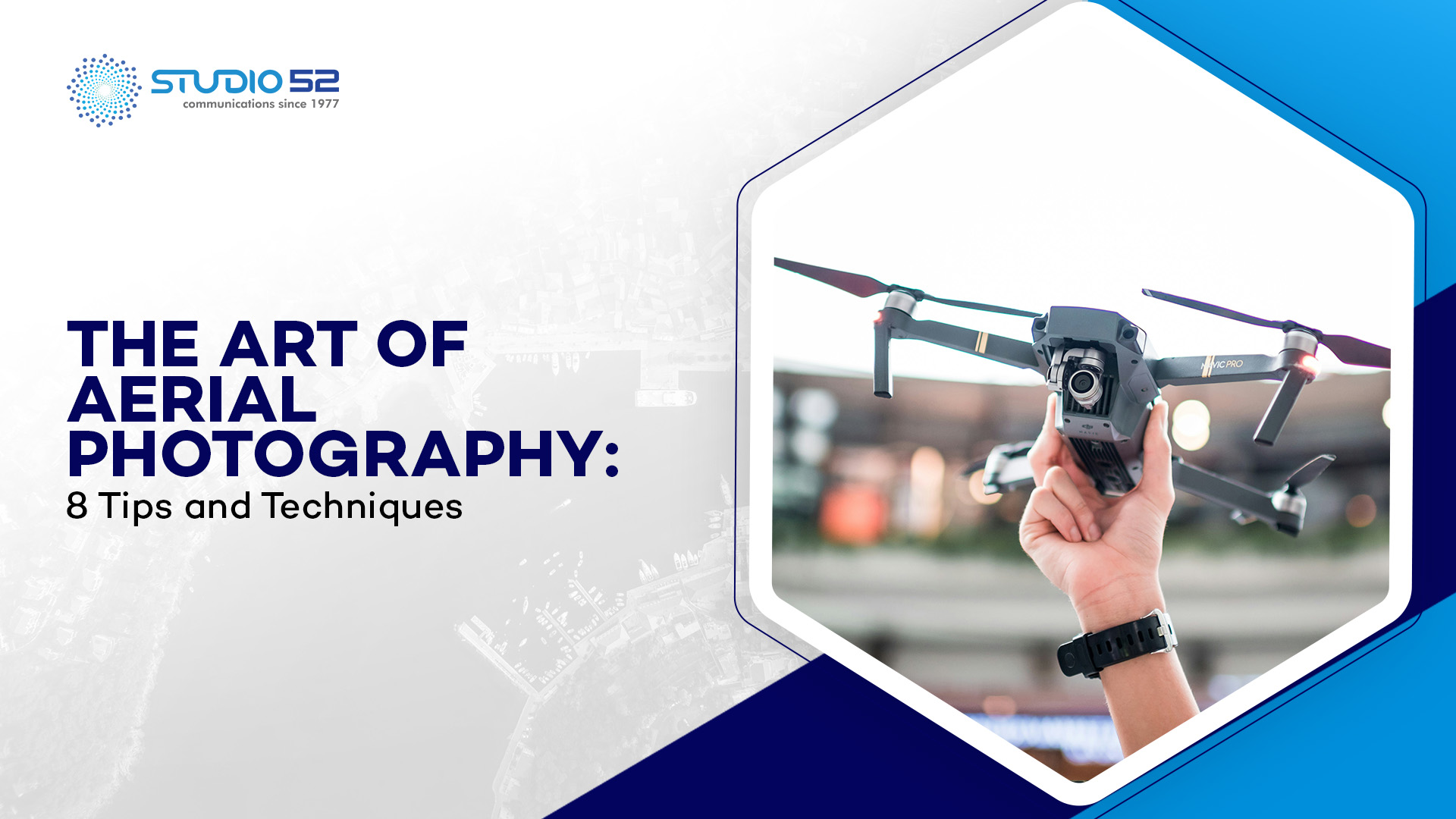
What is Aerial Photography?
Aerial photography is the way of taking photos from the air. Basically, aerial photography is the technique of shooting the Earth’s surface or highlights of its climate or hydrosphere from an elevated or direct-down position using a camera mounted on an aircraft, helicopter, balloon, rocket, kite, or skydiver.
In Saudi Arabia, professional drone photography services have transformed how aerial photography is conducted, making it more accessible, precise, and efficient. Drones offer a flexible, cost-effective, and high-resolution alternative to traditional aerial methods, whether for government infrastructure projects or private sector needs.
Aerial photos are important for obtaining useful data and insights about a given area. Today, aerial photography is being used extensively in Saudi Arabia for agricultural management, forestry, pollution monitoring, urban planning, conservation, wildlife management, and more. From mapping remote desert terrains to monitoring coastal development along the Red Sea, aerial imaging continues to play a vital role in national development.
Discover how aerial drone video and photography can transform your visual storytelling with high-impact, cinematic views for marketing, real estate, and more.
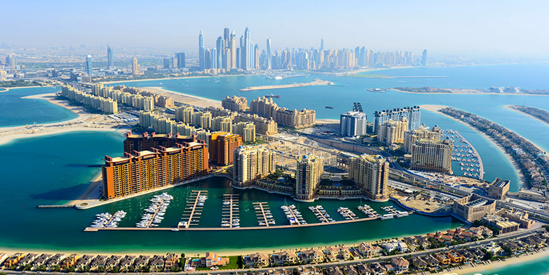
Table of Content
History of Aerial Photography
French photographer and balloonist Gaspar Felix Tournachon, also known as “Nadar“, was the first man known to take an aerial photograph. This historic image captured a view of the village Petit-Becetre in France, taken from a tethered hot-air balloon 80 meters above the ground. Considering the complexity of the early collodion photographic process, it was a remarkable achievement for the time.
As photographic technology progressed, it became easier for photographers to venture into the skies using hot-air balloons. But balloons weren’t the only carriers—kites, pigeons, and even rockets were employed to lift cameras for capturing images from above.
The invention of the airplane by the Wright brothers revolutionized aerial photography. In 1909, Wilbur Wright, though not a photographer, took the first aerial photograph from an airplane as part of a marketing effort to sell his planes to the Italian government. This could be considered the first instance of commercial real estate drone photography in spirit, as aerial photos began to serve marketing and promotional purposes.

During World War II, aerial imagery became widespread in newspapers, magazines, and newsreels. After the war, aerial photography was adapted for non-military use. Notably, Sherman Fairchild created an aerial map of Manhattan Island using a series of overlapping photographs—ushering in the era of land surveying and mapping by air.
Until recently, aerial photography was largely limited to military use, hobbyists, and individuals with access to helicopters or aircraft. It wasn’t until around 2013 that drone technology took off commercially.
The arrival of drones equipped with high-resolution cameras, combined with regulatory permissions, sparked an explosion in applications like commercial real estate drone photography, urban planning, tourism, and more. In Saudi Arabia, this trend continues to rise, especially with drone services being used to capture large-scale developments and property listings from dynamic new angles.
What are the Different Types of Aerial Photography?
In 2025, aerial photography has evolved significantly, especially with the widespread use of drones and advanced imaging technology across sectors in Saudi Arabia. Today, drone video production services are playing a major role in capturing everything from heritage sites in AlUla to urban mega-projects like NEOM and The Line.
Discover the best drones with 4k cameras to capture stunning aerial visuals and elevate your photography game.
Based on the camera axis and angle, here are the primary types of aerial photography used:
1. Vertical Photographs
These are taken with the camera axis positioned vertically, capturing imagery from a straight-down perspective. Although they cover a smaller area compared to oblique photos, vertical images are highly accurate and widely used for cartography, construction planning, and agriculture mapping across regions like Riyadh and the Eastern Province.
2. Low Oblique Photographs
With the camera tilted slightly (more than 3 degrees), low oblique images do not show the horizon. They are excellent for showcasing building facades, infrastructure, and landscape features. In Saudi Arabia, this style is often used in real estate listings and tourism campaigns, especially around the Red Sea coast, using professional drone video production services to add dynamic visual appeal.
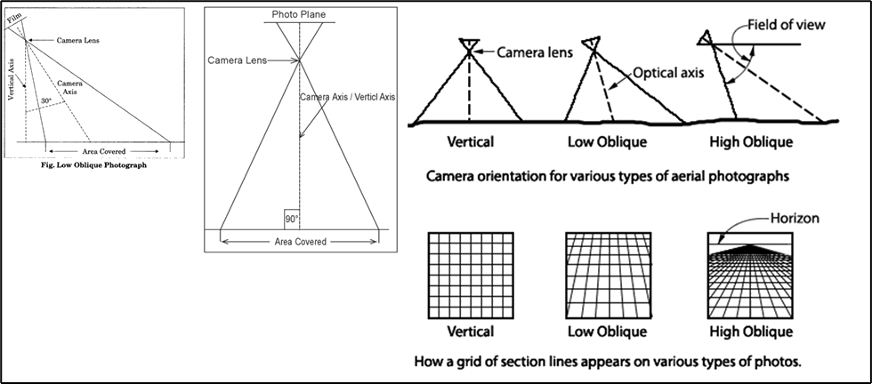
3. High Oblique Photographs
Here, the camera is tilted around 60 degrees to capture wider landscapes, including the horizon. These are great for panoramic views of expansive developments like Qiddiya or for documenting desert topography and natural reserves, useful in environmental studies and tourism.
4. Panoramic Aerial Photography
A 360-degree panoramic aerial shot, often captured using a drone equipped with a rotating gimbal or multiple lenses. These immersive visuals are increasingly used in virtual tours, especially by Saudi developers showcasing resorts, universities, and smart cities to global investors.
5. Thermal Aerial Photography
Utilizing infrared sensors mounted on drones, this technique is used to detect heat patterns in buildings, farmlands, or pipelines. In Saudi Arabia, it is gaining traction in renewable energy projects, agriculture, and oil & gas sectors for monitoring and inspection purposes.
6. Commercial Applications of Aerial Photography
The possibilities for aerial photography are expanding rapidly, especially with the integration of aerial drone videography into modern business strategies. In Saudi Arabia, where innovation and smart infrastructure are on the rise, drone services are transforming industries ranging from real estate to agriculture. Here are some of the most impactful commercial applications:
7. Real Estate Listings
With the Kingdom’s booming property market—from luxury villas in Riyadh to waterfront developments in Jeddah—drone services in Saudi Arabia are helping real estate professionals present listings with stunning aerial visuals. Projects like The Line and Diriyah Gate have leveraged aerial drone videography to showcase their scale, design, and surrounding landscape, making listings more dynamic and attractive.
8. Agriculture
Drone-based aerial photography is revolutionizing precision farming across large agricultural areas like Al-Qassim and Hail. Farmers use aerial imagery to assess crop health, identify irrigation issues, and improve yield forecasts more efficiently than ever before.
9. Inspection
Routine inspection of hard-to-reach infrastructure—such as Aramco oil pipelines, wind farms in Dumat Al Jandal, and large construction sites—is now safer and more efficient using aerial drone videography. These visuals help detect wear, damage, or misalignments quickly, reducing downtime and cost.
10. Advertisements
Tourism and leisure destinations in Saudi Arabia, including AlUla, NEOM’s Sindalah Island, and the Red Sea Project, have used breathtaking aerial visuals in promotional content. Whether it’s a golf course in KAEC or a desert resort in Tabuk, drone videography elevates visual storytelling in advertising.
11. Social Media & Websites
With a growing number of local businesses and influencers in Saudi Arabia building strong digital footprints, high-resolution aerial drone videography is an eye-catching way to boost social media presence and website engagement. Aerial content from Riyadh Season events and MDLBEAST Soundstorm festivals have gone viral for this very reason.
12. Construction
Construction firms involved in mega-projects like Qiddiya and King Salman Park use aerial photography and drone mapping to track site progress, monitor logistics, and generate reports. It’s also a powerful tool to avoid disputes through precise visual documentation.
13. Sports Photography
Drone videography has become a popular way to capture sporting events like the Formula E races in Diriyah and desert rally events such as Dakar Saudi Arabia. The dynamic angles and immersive perspectives add excitement to the viewing experience.
14. Cartography
Geospatial experts are using drones for updated mapping and city planning in emerging smart cities such as NEOM and King Abdullah Economic City (KAEC), helping planners create efficient road systems and utilities layouts.
15. Event Photography
Major events like the Riyadh Season, Saudi Cup (horse racing), and music festivals are now often documented using drone services in Saudi Arabia to capture grand aerial shots. These photos and videos are later repurposed for marketing, sponsorships, and promotions.
Discover how aerial videography in events and real estate marketing in Saudi Arabia with dynamic visuals and enhanced storytelling impact.
Wrapping Up!
The examples above are just the tip of the iceberg when it comes to how aerial drone photography is transforming businesses. From real estate to tourism, agriculture to events—drone services in Saudi Arabia are unlocking new levels of creativity, efficiency, and impact.
If you’re ready to take your visual storytelling to new heights, there’s no better time than now to partner with a trusted name like Studio52. With our expert drone videography team and cutting-edge equipment, we deliver stunning aerial visuals that help define your brand and captivate your audience.
Planning to elevate your business? Reach out to us today or browse through our portfolio of past projects under “Aerial Photography” to see how we’ve helped businesses like yours soar.